South Shetland Islands Facts For Kids
The South Shetland Islands are a group of Antarctic islands located in the Drake Passage, covering an area of 3,687 km² and known for their unique ecosystems and geological features.

Do more with AI
Introduction
The South Shetland Islands are a fantastic group of islands located near Antarctica 🌏. They have a total area of 3,687 square kilometers, which is about 1,424 square miles! These islands are mostly covered in ice and snow, making them look very beautiful and magical 🌨️. They are surrounded by the cold waters of the Drake Passage, and teams of scientists explore these islands to learn more about our planet. There are different islands in this group, but the main ones include King George Island, Deception Island, and Livingston Island. Isn't that cool? 🏔️
Images of South Shetland Islands

L.L. Ivanov. Antarctica: Livingston Island and Greenwich, Robert, Snow and Smith Islands. Scale 1:120000 topographic map. Troyan: Manfred Wörner Foundation, 2010. ISBN 978-954-92032-9-5 (First edition 2009. ISBN 978-954-92032-6-4 )


Williams Point , Livingston Island in the South Shetland Islands ; the first land ever discovered south of 60˚ south latitude, on February 19, 1819. Left to right Slab Point , Organpipe Point , and Williams Point surmounted by Sayer Nunatak , from Miziya Peak , with Zavala Island in the foreground, Zed Islands in the left background, and Pyramid Island on the right Viewpoint location: Miziya Peak in Vidin Heights on Livingston Island, in the South Shetland Islands Viewpoint elevation: 604 meters Camera: HP PhotoSmart C945 (V01.54)

1822 chart of the South Shetland Islands and South Orkney Islands, Antarctica by George Powell (fragment)

Derelict Norwegian whaling boat on Half Moon Island in Antarctica

Ongal Peak in Tangra Mountains on Livingston Island, in the South Shetland Islands, with Levski Peak in the background. Viewpoint location: North slopes of Ongal Peak in Tangra Mountains on Livingston Island, in the South Shetland Islands Viewpoint elevation: 940 meters Camera: HP PhotoSmart C945 (V01.54)

L.L. Ivanov. Antarctica: Livingston Island and Greenwich, Robert, Snow and Smith Islands. Scale 1:120000 topographic map. Troyan: Manfred Wörner Foundation, 2010. ISBN 978-954-92032-9-5 (First edition 2009. ISBN 978-954-92032-6-4 )
Williams Point , Livingston Island in the South Shetland Islands ; the first land ever discovered south of 60˚ south latitude, on February 19, 1819. Left to right Slab Point , Organpipe Point , and Williams Point surmounted by Sayer Nunatak , from Miziya Peak , with Zavala Island in the foreground, Zed Islands in the left background, and Pyramid Island on the right Viewpoint location: Miziya Peak in Vidin Heights on Livingston Island, in the South Shetland Islands Viewpoint elevation: 604 meters Camera: HP PhotoSmart C945 (V01.54)
1822 chart of the South Shetland Islands and South Orkney Islands, Antarctica by George Powell (fragment)
Derelict Norwegian whaling boat on Half Moon Island in Antarctica
Image by Lyubomir Ivanov ( User:Apcbg ), licensed under Creative Commons Attribution-Share Alike 4.0Ongal Peak in Tangra Mountains on Livingston Island, in the South Shetland Islands, with Levski Peak in the background. Viewpoint location: North slopes of Ongal Peak in Tangra Mountains on Livingston Island, in the South Shetland Islands Viewpoint elevation: 940 meters Camera: HP PhotoSmart C945 (V01.54)
Flora And Fauna
Even though it's really cold, the South Shetland Islands are home to some amazing plants and animals! 🐧You can find moss, lichens, and a few types of flowering plants. Sea birds like petrels and gulls often nest here! The islands are also famous for their adorable penguins, like the Gentoo and Chinstrap penguins 🐧. Plus, you can see seals resting on the shores! The waters around the islands are rich with various fish and even whales. What an adventure it would be to visit them! 🌊
Climate And Weather
The weather in the South Shetland Islands is super cold! 🌬️ In summer, temperatures can reach about 6 degrees Celsius (43 degrees Fahrenheit) but often it's much colder. In winter, it can go down to -20 degrees Celsius (-4 degrees Fahrenheit)❄️. The islands experience strong winds and snow, especially during the winter months! Rain and fog are also common. Because of this chilly weather, only hardy animals and plants can survive in this icy land. 🌨️
Geological Features
The South Shetland Islands are made of volcanic rock, which means they were formed by eruptions a long time ago! 🌋Deception Island, one of the islands, has a volcanic crater that makes it special. The crater is called a caldera, and it even has hot springs! The islands have many glaciers, which are immense rivers of ice that slowly move and shape the land. It's fascinating to know that these geological features are key to understanding our Earth! 🌏
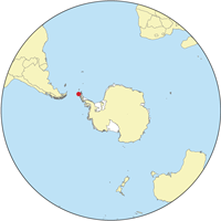
Geography And Location
The South Shetland Islands are situated to the north of the Antarctic Peninsula. 🗺️ The islands are located at coordinates 62 degrees south latitude and 59 degrees west longitude. They are part of the Southern Ocean and are about 120 kilometers from the coast of Antarctica ❄️. The islands are mostly rocky and steep, which makes them look like giant ice sculptures towering over the ocean. King George Island is the largest, and it is home to several research stations! 🌊
History And Exploration
The South Shetland Islands were discovered in 1819 by a British naval officer named Edward Bransfield. ⛵He and his crew were exploring the Antarctic region. Soon after, many explorers and scientists became interested in these islands! Over the years, whalers and sealers visited the area, using the islands as a safe stopping point. Today, many countries have research stations on the islands, helping us learn more about the chilly, mysterious world of Antarctica! 🌎
Cultural And Historical Significance
The South Shetland Islands hold special meaning to explorers and scientists. In the early 19th century, they were essential for whalers and sealers ⚓. Many famous Antarctic explorers started their journeys from these islands. Today, they remind us of the adventures humans have had in exploring our planet. The islands also serve as valuable research sites, helping us understand our environment and the effects of climate change. This blend of history and scientific discovery makes the South Shetland Islands a place of great importance! 📚
Conservation And Environmental Issues
The South Shetland Islands are important for wildlife, which is why conservation is so crucial! 🦭Several countries have made agreements to protect the animals and plants living there. One big issue is climate change, which is affecting ice levels and animal habitats. Scientists monitor this closely, helping to create plans to protect the wildlife. Always remember to respect nature, especially in such beautiful and delicate areas! 🌍
Human Activities And Research Stations
Many scientists from around the world come to the South Shetland Islands to do research! 🧑🔬 Countries like Argentina, Chile, and the United Kingdom have research stations there. These stations are where scientists study climate change, penguin populations, and the amazing ocean life 🐠. Summer is the busiest time, with researchers conducting important experiments. Sometimes, tourists come too, but they must always follow rules to protect the wildlife! 🏕️
Significant Islands Within The Archipelago
The South Shetland Islands have several important islands. King George Island is the largest and has many research stations 🏢. Deception Island is famous for its volcanic activity and beautiful landscapes. Livingston Island is home to many penguins and stunning glaciers ⛷️. Other notable islands include Elephant Island, known for its wildlife, and Greenwich Island, rich in history. Each island is unique and contributes to the incredible story of the South Shetland Islands! 🏝️
South Shetland Islands Quiz
Learn more about South Shetland Islands