Atlas Facts For Kids
Atlas is a Titan from Greek mythology known for bearing the weight of the heavens on his shoulders as punishment for siding with the Titans in their war against the Olympians.

Do more with AI
Introduction
Atlas is a giant in Greek mythology known for carrying the weight of the world on his shoulders. 🌍He is often depicted as a strong muscular figure, holding up the sky or a globe. According to myths, Atlas was punished by the god Zeus for fighting against him in the Titan War. 🌩️ This is why he has to carry the world. Atlas also has a connection to astronomy and geography because he was said to hold up the heavens itself. Today, people use the name "Atlas" for books of maps that help us navigate the Earth!
Images of Atlas
![The Maghreb (south-up) in Muhammad al-Idrisi's Nuzhat al-Mushtāq (نزهة المشتاق في اختراق الآفاق), also known as the Tabula Rogeriana (12th century).[2]](https://upload.wikimedia.org/wikipedia/commons/thumb/9/9f/89v_90r_%D9%86%D8%B2%D9%87%D8%A9_%D8%A7%D9%84%D9%85%D8%B4%D8%AA%D8%A7%D9%82_Arabe_2221_BNF.jpg/960px-89v_90r_%D9%86%D8%B2%D9%87%D8%A9_%D8%A7%D9%84%D9%85%D8%B4%D8%AA%D8%A7%D9%82_Arabe_2221_BNF.jpg)
The Maghreb (south-up) in Muhammad al-Idrisi's Nuzhat al-Mushtāq (نزهة المشتاق في اختراق الآفاق), also known as the Tabula Rogeriana (12th century).[2]

World map Theatrum Orbis Terrarum (Theatre of the Orb of the World) by Abraham Ortelius, 1570

Joan Blaeu's world map, originally prepared by Blaeu for his Atlas Maior, published in the first book of the Atlas van Loon (1664).

Imperii Orientalis et Circumjacentium Regionum by Guillaume Delisle (1742)

Map of England and Wales by Christopher Saxton, Atlas of the Counties of England and Wales, 1579
The Maghreb (south-up) in Muhammad al-Idrisi's Nuzhat al-Mushtāq (نزهة المشتاق في اختراق الآفاق), also known as the Tabula Rogeriana (12th century).[2]
World map Theatrum Orbis Terrarum (Theatre of the Orb of the World) by Abraham Ortelius, 1570
Joan Blaeu's world map, originally prepared by Blaeu for his Atlas Maior, published in the first book of the Atlas van Loon (1664).
Imperii Orientalis et Circumjacentium Regionum by Guillaume Delisle (1742)
Map of England and Wales by Christopher Saxton, Atlas of the Counties of England and Wales, 1579
Types Of Atlases
There are several types of atlases, each designed for different uses! 📖A general atlas has maps of the entire world, showing countries, cities, and oceans. A thematic atlas focuses on specific topics like climate, population, or wildlife. 🦓For example, a historical atlas may highlight events in different places over time. Another type is a road atlas, great for finding routes while driving. 📍There are even educational atlases for kids that are colorful and easy to understand! Each atlas serves a special purpose in helping us understand our world better!
History Of Atlases
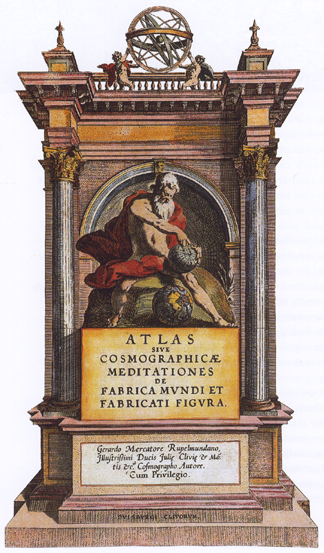
The word "atlas" comes from the name of Atlas in Greek mythology. The first known atlas was created in the 16th century by a man named Gerardus Mercator. 🗺️ He made maps that helped sailors find their way across the sea. Many people also started to call collections of maps "atlases" in honor of Atlas, the Titan. In 1595, Mercator published a book filled with beautiful maps, which helped to share knowledge about the world. 📚This was a very important event because it helped to connect different countries through mapping.
Famous Cartographers
Famous cartographers who made significant contributions to mapping include Gerardus Mercator, who created the Mercator Projection map in 1569. This map made it easier for sailors to navigate! 🧭Another famous cartographer is Martin Waldseemüller, who created one of the first world maps to use the name "America" in 1507. 🗺️ Other notable figures include Ptolemy, an ancient Egyptian geographer known for guiding explorers, and John Speed, an English cartographer famous for his detailed county maps. Each of these cartographers shaped how we understand our planet today!
The Science Of Cartography
Cartography is the art and science of making maps. 🎨It comes from the Greek words "karto," meaning "map," and "grapho," meaning "to write." Cartographers study the Earth's surface, including landforms, water bodies, and human-made structures, to create accurate maps. 🏔️ They use tools like GPS, satellites, and special software to gather information. Since the Earth is round, cartographers also have to figure out how to represent it in two dimensions! 📐This science helps us visualize our world and navigate through cities, countries, and even oceans!
Important Atlases In History
One of the most famous atlases in history is the "Theatrum Orbis Terrarum" created by Abraham Ortelius in 1570. 🗺️ This was the first modern atlas and included many detailed maps of countries. Another important atlas is the "National Geographic Atlas of the World," first published in 1963, which is known for its beautiful photographs and detailed maps. 🌄It shows us how geography shapes our planet! Other influential atlases include the "World Atlas" and "Merriam-Webster's Atlas," both of which also helped many people learn about the world around them.
Uses Of Atlases In Education
Atlases are great tools for education, helping students learn about geography and cultures! 🌎Teachers use atlases in classrooms to show students where countries and cities are located. ✏️ They can practice reading maps and understanding scales, helping them become more map-savvy. Atlases also encourage students to explore various topics such as climate, landforms, and populations. 📊Besides geography, they spark curiosity about history and cultures from different regions. Using atlases in school helps students develop important skills like critical thinking and spatial awareness, making learning exciting! 📚
Digital Atlases And Technology
Digital atlases are the modern way to explore maps using computers and smartphones! 📱They use technology like satellite images and GPS to show real-time locations. Google Maps is one of the most popular examples, allowing users to find directions, look at street views, and even explore famous landmarks around the world! 🕌Digital atlases can also include interactive features, like zooming in on specific areas or searching for points of interest. Additionally, some digital maps allow people to share their favorite places, making it fun for families to plan trips together! ✈️
Cultural Significance Of Atlases
Atlases play an essential role in our understanding of different cultures around the world. 🌏They show people where countries are located, their borders, and important cities. Through maps, we can see how geography affects history, travel, and even language! For instance, maps can help us understand trade routes that connected different cultures. 🛤️ Furthermore, atlases often include flags, capital cities, and important monuments. This helps children and adults learn about traditions and landmarks that are unique to each place, fostering respect and curiosity about diverse cultures!
Atlas Quiz
Learn more about Atlas
