Supercell Facts For Kids
A supercell is a highly organized thunderstorm characterized by a rotating updraft and capable of producing severe weather events like tornadoes and large hail.


Do more with AI
Introduction
Did you know that supercells are a special type of storm? 🌩️ They are huge, powerful thunderstorms that can produce tornadoes and heavy rain! Supercells are different from regular thunderstorms because they have a spinning updraft of air called a mesocyclone. These storms usually happen in places like the United States, especially in Tornado Alley, which includes parts of Texas, Oklahoma, and Kansas. Supercells can last for hours and travel many miles, making them one of the most fascinating—and sometimes dangerous—weather phenomena to learn about! 🌪️
Images of Supercell

An example of a supercell in Piracicaba, southeastern Brazil, on June 27, 2025, featuring a mesocyclone, a tail cloud, and a developing downdraft/rain curtain on the left.

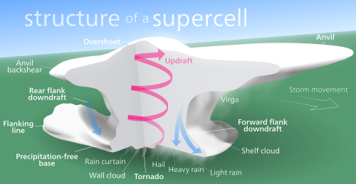
Schematic of a supercell's components

Wind shear (red) sets air spinning (green).

The updraft (blue) 'bends' the spinning air upwards.

The updraft starts rotating with the spinning column of air.
Structure of a supercell. Northwestward view in the Northern Hemisphere

Diagram of a supercell in the Northern Hemisphere from above. RFD: rear flank downdraft, FFD: front flank downdraft, V: V-notch, U: Main Updraft, I: Updraft/Downdraft Interface, H: hook echo

Radar reflectivity map

Schematics of an LP supercell
An example of a supercell in Piracicaba, southeastern Brazil, on June 27, 2025, featuring a mesocyclone, a tail cloud, and a developing downdraft/rain curtain on the left.
Schematic of a supercell's components
Wind shear (red) sets air spinning (green).
The updraft (blue) 'bends' the spinning air upwards.
The updraft starts rotating with the spinning column of air.
Structure of a supercell. Northwestward view in the Northern Hemisphere
Diagram of a supercell in the Northern Hemisphere from above. RFD: rear flank downdraft, FFD: front flank downdraft, V: V-notch, U: Main Updraft, I: Updraft/Downdraft Interface, H: hook echo
Radar reflectivity map
Schematics of an LP supercell
Supercell Tornadoes
Tornadoes that come from supercells are some of the strongest tornadoes! 🌪️ Tornadoes can reach speeds of over 300 miles per hour, which is faster than many cars! In the United States, the most common months for tornadoes to occur from supercells are April, May, and June. The Fujita Scale, which goes from F0 to F5, measures tornado strength. An F5 tornado can cause incredible damage, while an F0 tornado is much weaker. Scientists study these tornadoes to learn more about how to predict and warn about them effectively. 🦸♂️
Types Of Supercells
There are three main types of supercells: classic, high-precipitation (HP), and low-precipitation (LP). 🌩️ Classic supercells have a clear structure with a rotating updraft and may create tornadoes. High-precipitation supercells can produce a lot of rain, making it hard to see what's happening inside. They often have dangerous flash floods. 🌧️ Low-precipitation supercells, on the other hand, have less rain and can still create tornadoes! Each type has its own unique characteristics and can cause different weather events, so understanding them is important! 🌪️
Famous Supercell Events
There have been many famous supercell events throughout history! One of the most well-known was the 1996 Fort Worth tornadoes in Texas, where a supercell produced multiple tornadoes in a short time. 🌪️ Another notable event was the Joplin tornado in Missouri in 2011, which caused lots of destruction and showed the power of supercells. Also, the Tri-State Tornado of 1925 was a supercell tornado that traveled across three states—Missouri, Illinois, and Indiana! This tornado remains one of the deadliest in U.S. history. 📚Learning about these events helps us improve our safety measures!
Formation Of Supercells
Supercells form under certain weather conditions. 🌥️ It all starts when warm, moist air rises from the ground. This air meets cool, dry air high in the atmosphere. When this happens, the warm air starts to spin and creates the mesocyclone! For a supercell to form, there needs to be strong wind shear, which means the wind changes speed and direction with height. This twisting motion helps the storm stay strong and organized. Scientists use special radars to spot these storms, and they study them to understand how they work. 🌪️
Supercell Thunderstorms
Supercell thunderstorms are powerful and can be quite dangerous! They can create very heavy rain and lightning ⚡, and sometimes even hail. Supercells can produce winds over 100 miles per hour and can even make tornadoes! Scientists study supercells to better understand where and when they form. Weather prediction helps keep people safe by alerting them to storms in their area. 📰Meteorologists use Doppler radar to detect the rotation that indicates a supercell is forming. Learning to recognize storm warnings can help keep you safe when severe weather hits! 🚧
Characteristics Of Supercells
Supercells are big, spiraling storms 🚀 that can be recognized by their towering structure. They often have an anvil-shaped top called the overshooting top, which can reach heights of 10 miles into the atmosphere! This is where the storm cools and spreads out. Supercells can also produce hail, which are ice balls that can be as big as golf balls! ⚾Because of their rotating updrafts, supercells can be long-lasting, sometimes for hours or even longer. They also have distinct colors, often showing greens or yellows, which can tell us about the storm’s strength! 🌈
Mitigation And Safety Measures
To stay safe during supercell storms, it's essential to have a plan! 🛑Always listen to weather alerts on TV, radio, or apps, so you know when a storm is coming. Make a family emergency plan and know where to go in case of tornadoes. It’s good to have a weather radio and a safe spot in your house, like a basement or a bathroom without windows. During a severe storm, stay indoors and away from windows! Remember, always take storms seriously, and stay safe! 😊Knowing what to do can keep you and your family protected.
Potential Hazards From Supercells
Supercells can be very hazardous! 🌪️ One big danger is tornadoes, which can cause destruction to homes and trees. They can form very quickly, making it essential for people to prepare in advance. Heavy rain from supercells can lead to flash floods 🌊, which can be dangerous for people and animals. Strong winds can knock down power lines and trees, causing even more problems. It’s crucial to know where to go if a tornado warning is issued, like heading to a basement or an interior room of a sturdy building.
Supercell Quiz
Learn more about Supercell
