Sahara Facts For Kids
The Sahara is Earth's largest hot desert across North Africa, and its huge, varied landscapes matter because they hide many places and stories.


Do more with AI
Images of Sahara

Geographical map of the Sahara

The main biomes in Africa
A 2002 satellite image of the Sahara by NASA WorldWind

An oasis in the Ahaggar Mountains. Oases support some life forms in extremely arid deserts.

Sand dunes in the Algerian Sahara

Camel train at sunset in the Sahara

Vegetation and water bodies in early Holocene (top), between about 12,000 and 7,000 years ago, and Eemian (bottom)

Sahel region of Mali
![The Great Green Wall, participating countries and Sahel. In August 2023, it was reported that the GGW had only covered 18% of the planned area.[39]](https://upload.wikimedia.org/wikipedia/commons/thumb/5/57/Great_green_wall_map.svg/500px-Great_green_wall_map.svg.png)
The Great Green Wall, participating countries and Sahel. In August 2023, it was reported that the GGW had only covered 18% of the planned area.[39]
Geographical map of the Sahara
The main biomes in Africa
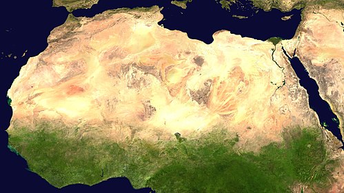
A 2002 satellite image of the Sahara by NASA WorldWind
An oasis in the Ahaggar Mountains. Oases support some life forms in extremely arid deserts.
Sand dunes in the Algerian Sahara
Camel train at sunset in the Sahara
Vegetation and water bodies in early Holocene (top), between about 12,000 and 7,000 years ago, and Eemian (bottom)
Sahel region of Mali
The Great Green Wall, participating countries and Sahel. In August 2023, it was reported that the GGW had only covered 18% of the planned area.[39]
Geographical map of the Sahara
The main biomes in Africa
A 2002 satellite image of the Sahara by NASA WorldWind
An oasis in the Ahaggar Mountains. Oases support some life forms in extremely arid deserts.
Sand dunes in the Algerian Sahara
Camel train at sunset in the Sahara
Vegetation and water bodies in early Holocene (top), between about 12,000 and 7,000 years ago, and Eemian (bottom)
Sahel region of Mali
The Great Green Wall, participating countries and Sahel. In August 2023, it was reported that the GGW had only covered 18% of the planned area.[39]
Introduction
Sahara is the largest hot desert on Earth. It covers about 9.2 million square kilometers across North Africa, which is nearly one third of the whole continent. Because of its huge size, the Sahara feels like a world of its own with long sandy plains, rocky plateaus, and lonely mountains.
The name comes from an Arabic word that means “desert.” The Sahara reaches from the Mediterranean and the Red Sea in the north and east all the way to the Atlantic Ocean in the west. It can look empty, but it hides many kinds of places and stories—what do you think lives there?
Climate And Weather
The Sahara is one of the hottest places on Earth. In the hottest months daytime temperatures often climb above 38–40 °C (100–104 °F). The desert has very clear skies and little moisture, so it gets strong sunshine. Because there are few clouds, nights cool down a lot, sometimes by 13–20 °C (23–36 °F). High places can even drop below freezing on winter nights.
Rain in the Sahara is rare and uneven. The center is hyper-arid, getting almost no rain. Edges get more, maybe 100–250 mm a year, and plants grow there. Evaporation is huge, so any water that falls usually disappears fast. Snow has even fallen once or twice in some high towns.
Ecoregions And Life
The Sahara is not the same everywhere. Along the Atlantic coast a narrow strip gets fog and supports succulents and lichens. The northern edge has steppe and woodlands that receive winter rains. The central part is a very dry desert with only a few hardy plants and lots of bare rock or sand.
Highlands like the Tibesti and Aïr are cooler and can support more trees and shrubs. Wadis and oases collect water and allow palms, grasses, and small farms to grow. Animals like camels, fennec foxes, addax antelope, and many birds have special ways to live with heat and little water.
Geography And Landforms
Most of the Sahara is not endless sand but hard, rocky ground called hamada. Big areas of loose sand called ergs make up only part of it. Some sand dunes in these ergs grow taller than a 50-story building—over 180 meters high. Between these features are gravel plains, salt flats, and dry lake beds.
You also find narrow dry riverbeds called wadis that fill with water after rare rains. In the middle of the desert rise mountain ranges like the Aïr, Ahaggar, and Tibesti. Their peaks can be cooler and hold more plants than the flat desert around them.
History And Ancient Peoples
Long ago the Sahara was wetter and had lakes and rivers. People lived there in societies that hunted, fished, and later farmed. The Kiffian culture lived around 10,000–8,000 years ago near a large lake and left big graves at a place called Gobero. Later, after a dry time, the Tenerian people lived there and buried their dead with jewelry and pots.
Other early people built stone circles at Nabta Playa that show careful planning of the sky and seasons. By about 500 BCE a desert kingdom called the Garamantes used deep tunnels to reach underground water and farm in the Sahara. When water ran out, their towns slowly changed.
Peoples, Languages, And Cities
Many different groups live in and near the Sahara. The Berber peoples, including the Tuareg, are long-time desert dwellers who travel, herd animals, and trade across the sands. Arabic is widely spoken because people in the region use it for trade and religion. Near the desert edges other languages like Hausa and Songhai are common in towns.
Several cities sit on the Sahara’s edges or inside it. Timbuktu grew into a famous center for trade and learning. Other important towns include Nouakchott, Tamanrasset, Agadez, Ghat, and Faya-Largeau. Life in these places mixes desert traditions with modern ways of living.
Did you know?
🏜️ The Sahara is the largest hot desert in the world, covering 9.2 million square kilometers.
🗣️ The name 'Sahara' comes from the Arabic word for 'desert'.
☀️ The Sahara gets more than 3,600 hours of bright sunshine every year.
🌡️ In summer, many parts of the Sahara have average highs above 40°C, and sand can warm up to 83.5°C during the day.
🌿 About 2,800 species of vascular plants live in the Sahara, and a quarter of them are found only there.
🦊 Animals such as the fennec fox, the pale fox, and Rüppell's fox live in the Sahara.
Sahara Quiz
Learn more about Sahara
Frequently Asked Questions
