Pannonian Basin Facts For Kids
The Pannonian Basin, also known as the Carpathian Basin, is a large sedimentary basin in Southeast Central Europe, surrounded by mountains and known for its rich agricultural lands and diverse cultures.

Do more with AI
Introduction
The Pannonian Basin is a big flat area in Southeast Central Europe! 🌍It covers countries like Hungary, Serbia, Austria, and parts of Croatia. This special place is shaped like a bowl and was formed millions of years ago when the sea dried up. 🌊The Pannonian Basin is known for its rich soil, making it great for farming! It is also home to many rivers and lakes. People have lived here for a long time, and it has a rich history! Let’s explore the cool things about the Pannonian Basin together! 🌱
Images of Pannonian Basin

The Pannonian Basin (III), enclosed by the Carpathian Mountains and Transylvanian Plateau (IV) to the east and north. Also shown are the Wallachian Plain (II) and the Outer Subcarpathian depressions (I)

A farm on the Hortobágy National Park

The Danube-Tisa-Danube Canal near the village of Rumenka, close to Novi Sad
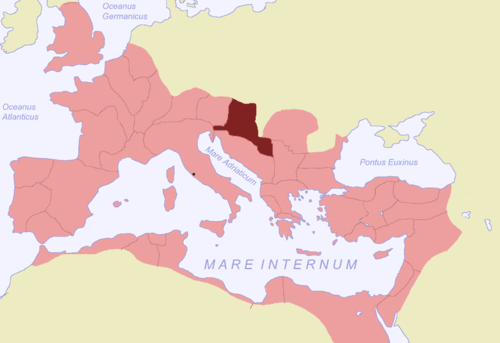
Pannonia within the Roman Empire

The Pannonian mixed forests cover the extent of the plain

Buchlov Nature Reserve near the edge of the basin
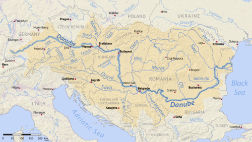
Map of the Danube

The Biogeographic regions of Europe. The Pannonian Basin is shown in orange

A wheat field near Temerin
The Pannonian Basin (III), enclosed by the Carpathian Mountains and Transylvanian Plateau (IV) to the east and north. Also shown are the Wallachian Plain (II) and the Outer Subcarpathian depressions (I)
A farm on the Hortobágy National Park
The Danube-Tisa-Danube Canal near the village of Rumenka, close to Novi Sad
Pannonia within the Roman Empire
The Pannonian mixed forests cover the extent of the plain
Buchlov Nature Reserve near the edge of the basin
Map of the Danube
The Biogeographic regions of Europe. The Pannonian Basin is shown in orange
A wheat field near Temerin
Conservation Efforts
Many people love the Pannonian Basin and want to protect it! 🦋Various organizations work on conservation projects to save endangered species and habitats. They plant trees, clean rivers, and educate the community about nature. National parks help keep wildlife safe and promote tourism! 🌳Everyone can help by recycling, conserving water, and respecting nature. Together, we can keep the Pannonian Basin a fantastic place for many years to come! 🌻
Environmental Issues
The Pannonian Basin faces some environmental challenges. 🌍Pollution from factories and cars can harm the air and water quality. Over-farming can also cause soil erosion, making it hard for plants to grow. Protecting wetlands is essential for many animals’ habitats! 🌊So, it’s important for people to take care of the environment to keep this beautiful area healthy and thriving. 🌱
Geological Formation
A long, long time ago, the Pannonian Basin was covered by water! 🌊Around 20 million years ago, tectonic plates shifted, and the sea began to dry up, leaving behind rocks and soil. The basin is filled with sediment, which is mud, sand, and stones that settled over time. This makes the land very fertile and perfect for growing crops! 🌾Geologists study these old rocks to learn more about how the Earth was formed!
Geography And Location
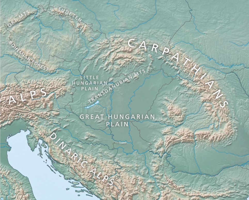
The Pannonian Basin is surrounded by beautiful mountains! ⛰️ To the north, you’ll find the Alps, and to the east, the Carpathians. This basin is like a big green carpet of fields and forests. It is mostly in Hungary, which is known for its capital, Budapest. Did you know the Danube River, one of Europe’s longest rivers, flows through the basin? 🚤The basin is about 93,000 square kilometers (36,000 square miles) and has various landscapes like hills, plains, and rivers!
Agriculture And Economy
Farming is super important in the Pannonian Basin! 🌽The fertile soil allows farmers to grow lots of crops like corn, wheat, and sunflowers. Hungary is one of the world's top producers of paprika, a yummy spice! 🥫Vineyards are also found here, making delicious wines! 🍷Besides farming, industries like manufacturing and tourism are important in the economy. Many visitors come to explore its charming towns and beautiful nature!
Major Cities And Landmarks
The Pannonian Basin is home to some amazing cities! 🌆Budapest, the capital of Hungary, has stunning landmarks like the Parliament Building, Buda Castle, and the famous Chain Bridge! Other important cities are Szeged and Debrecen. Don’t forget about Lake Balaton, the largest lake in Central Europe! 🏞️ It’s a popular spot for swimming and sailing. The Pannonian Basin has many national parks where people can enjoy nature, such as Hortobágy National Park, known for its unique landscapes!
Biodiversity And Ecosystems
The Pannonian Basin is home to many plants and animals! 🦋You can find colorful flowers, tall grasses, and even some rare species like the Great Bustard, a big bird! 🦩The rivers and lakes support fish like carp and catfish. Various forests house animals such as deer, foxes, and squirrels! 🐿️ The basin has different ecosystems, including wetlands, grasslands, and forests, making it a vital habitat for many living creatures!
Climate And Weather Patterns
The Pannonian Basin has a continental climate! 🌦️ That means it has hot summers and cold winters! In summer, temperatures can reach up to 30°C (86°F), while in winter, it can drop to -5°C (23°F) or colder! The region receives moderate rainfall, especially in spring and autumn, helping plants and crops to grow. 🌼The weather can change quickly, so residents always keep an eye on the sky! 🌈
Cultural History And Heritage
The Pannonian Basin has a rich cultural history! 🏺People have lived here for thousands of years. The Romans, Magyars, and Ottomans have all called it home. The famous city of Budapest is famous for its beautiful castles, baths, and bridges! 🏰Many festivals celebrate local traditions, such as folk dances and food. Traditional dishes, like goulash, are popular! 🍲The blend of different cultures makes this area unique and vibrant!
Transportation And Infrastructure
Getting around the Pannonian Basin is easy! 🚆There are many railways, roads, and highways connecting cities and towns. Trains are a popular way to travel. ✨The Budapest Metro is one of the oldest in the world! 🚇People use buses and trams in cities. Airports in major cities also help travelers fly to new places. This strong infrastructure helps everyone move and explore this fascinating region! ✈️
Pannonian Basin Quiz
Learn more about Pannonian Basin
