Niger River Facts For Kids
The Niger River is a vital waterway in West Africa, known for its historical significance, ecological diversity, and geographical importance.


Do more with AI
Introduction
The Niger River is the third-longest river in Africa, flowing about 4,180 kilometers (2,600 miles)! 🌍It starts in the Guinea Highlands in West Africa and travels through several countries, including Mali, Niger, and Nigeria. The river is important for the people who live near it as it provides water for drinking, farming, and fishing! 🎣It is also known for its winding shape, somewhat like a letter "S"! The Niger River has many tributaries, which are smaller rivers that flow into it, making it even bigger and fuller! 💧
Images of Niger River

Commercial activity along the river front at Boubon, in Niger

The great bend of the Niger River, seen from space, creates a green arc through the brown of the Sahel and Savanna. The green mass on the left is the Inner Niger Delta, and on the far left are tributaries of the Senegal River.

Mud houses on the center island at Lake Debo, a wide section of the Niger River

Boy bringing back his canoe on the Niger River (2022)
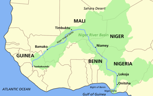
Map of the Niger, showing its watershed and "inland delta"

River Niger at Bomadi

Growing African rice, Oryza glaberrima along the Niger River in Niger. The crop was first domesticated along the river.

A reconstruction of the Ravenna Cosmography placed on a Ptolemaic map. The River Ger is visible at bottom. Note it is placed, following Ptolemy, as just south of the land of the Garamantes, in modern Libya, constricting the continent to the land from the central Sahara north.

1561 map of West Africa by Girolamo Ruscelli, from Italian translation of Ptolemy's Atlas "La geografia di Claudio Tolomeo alessandrino, Nuovamente tradotta di Greco in Italiano". The writer was attempting to square information gleaned from Portuguese trade along the coast with Ptolemy's world map. The mouths of the Senegal River and Gambia River are postulated to flow into a lake, which also feeds the "Ger"/"Niger River", which in turn feeds the "Nile Lake" and Nile River.
Commercial activity along the river front at Boubon, in Niger
The great bend of the Niger River, seen from space, creates a green arc through the brown of the Sahel and Savanna. The green mass on the left is the Inner Niger Delta, and on the far left are tributaries of the Senegal River.
Mud houses on the center island at Lake Debo, a wide section of the Niger River
Boy bringing back his canoe on the Niger River (2022)
Map of the Niger, showing its watershed and "inland delta"
River Niger at Bomadi
Growing African rice, Oryza glaberrima along the Niger River in Niger. The crop was first domesticated along the river.
A reconstruction of the Ravenna Cosmography placed on a Ptolemaic map. The River Ger is visible at bottom. Note it is placed, following Ptolemy, as just south of the land of the Garamantes, in modern Libya, constricting the continent to the land from the central Sahara north.
1561 map of West Africa by Girolamo Ruscelli, from Italian translation of Ptolemy's Atlas "La geografia di Claudio Tolomeo alessandrino, Nuovamente tradotta di Greco in Italiano". The writer was attempting to square information gleaned from Portuguese trade along the coast with Ptolemy's world map. The mouths of the Senegal River and Gambia River are postulated to flow into a lake, which also feeds the "Ger"/"Niger River", which in turn feeds the "Nile Lake" and Nile River.
Economic Impact
The Niger River significantly impacts the local economy! 💰Farmers use the river for irrigation, helping them grow crops like rice, millet, and sorghum. Fishing is also a major industry, providing food and jobs for many families! 🎣The river supports transportation, allowing people to move goods and travel between towns and cities. Traders move products like cotton, fish, and vegetables along its waters, contributing to the economy of the surrounding areas! Additionally, tourism around the river attracts many visitors, bringing new opportunities! 🌅
Cultural Importance
The Niger River has great cultural significance for the people living nearby! 🎭Many communities have traditions and festivals celebrating the river, like fishing contests and cultural dances. The river is also featured in folk tales and songs, carrying history and stories from generation to generation! 🌠The vibrant markets along the riverbanks are filled with crafts, food, and art that tell stories of the local culture. Many people are also involved in riverboat tourism, sharing their customs with travelers from around the world! 🚤
Geography And Course
The Niger River flows through five countries: Guinea, Mali, Niger, Benin, and Nigeria. 🌐It begins in the lush mountains of Guinea, then goes through the dry Sahel region, and finally empties into the Atlantic Ocean. The river's basin, which is like a huge area that collects water, covers about 2.1 million square kilometers (800,000 square miles)! 🌊One of its famous bends is called the "Niger River Loop," found in Mali, where the river makes a big twist! This river helps create beautiful landscapes and fertile lands along its banks! 🏞️
Historical Significance
The Niger River has been important for thousands of years! 🌌Ancient cities like Timbuktu, located along the river in Mali, were once trade centers for gold, salt, and spices. These cities helped cultures and ideas mix through trade and education! The river also played a role in the spread of Islam in West Africa during the 7th century. 📜Several famous explorers, such as Mungo Park, traveled along the river in the late 1700s, helping to map the area and learn more about the people who live there! Their adventures opened new paths for exploration and trade! ⚓
Ecology And Biodiversity
The Niger River is home to many plants and animals! 🐊You'll find fish like Catfish and Tilapia, which are important for local diets. The river also supports animals like hippopotamuses and crocodiles! 🦙The riverbanks are filled with lush greenery, and many birds, such as kingfishers and herons, live in these habitats. 🌿Many fishermen and farmers depend on this biodiversity for their livelihoods, making the river crucial for both people and wildlife. Protecting this ecosystem is very important for the river's health! 🌏
Land Use And Agriculture
People living near the Niger River have used the land for agriculture for centuries! 🌱They grow many crops, including rice, maize, and yams, taking advantage of the river's rich soil. Farmers often use traditional methods and work together in communities to plant and harvest their crops. 🌾The river also provides a source of water for both crops and livestock like cattle, sheep, and goats! Some areas even have fish farms where fish are raised and harvested for food. This close connection to the land and river helps many communities thrive and stay connected! 🐟
Challenges And Conservation
The Niger River faces several challenges that threaten its health. 🌊Pollution from industries and plastic waste can harm the river's ecosystem. Also, climate change causes irregular rainfall, which affects water levels! 🌞To help protect the river, many local and international organizations work together on conservation projects. They aim to reduce pollution, restore habitats, and promote sustainable fishing and farming practices. 🌳People are also educated about the importance of caring for the river, creating a sense of responsibility toward its future!
Notable Cities And Landmarks
There are several notable cities and landmarks along the Niger River! 🏙️ The city of Timbuktu in Mali is famous for its ancient mosques and university, attracting many visitors! The city of Niamey is the capital of Niger and is known for its vibrant markets and cultural scene! 🌍The old city of Gao in Mali has historical significance and is home to various archaeological sites! 🕌The Niger River also has beautiful natural spots like the Niger River delta, home to stunning wetlands and diverse wildlife! 🚀Overall, the river hosts a rich tapestry of cities and landmarks that brighten its banks! 🌟
Niger River Quiz
Learn more about Niger River
