Latitude Facts For Kids
Latitude is a geographical coordinate that defines the north-south position of a point on Earth, measured in degrees from the Equator.


Do more with AI
Introduction
Latitude is a special way to find your position on Earth! 🌍Imagine the Earth as a giant orange. If you cut it in half, you have two sides - the top is the North Pole, and the bottom is the South Pole. Latitude lines are horizontal lines that run across the Earth, telling us how far north or south a place is from the Equator, which is an imaginary line in the middle of the globe. The Equator is at 0 degrees latitude, while the North Pole is at 90 degrees North, and the South Pole is at 90 degrees South. Pretty cool, right? 😊
Images of Latitude

Earth model with circles of latitude in black and indications of the North Pole, Equator, and the northern and southern hemispheres.

A perspective view of the Earth showing how latitude ( ϕ {\displaystyle \phi } ) and longitude ( λ {\displaystyle \lambda } ) are defined on a spherical model. The graticule spacing is 10 degrees.
The orientation of the Earth at the December solstice


The definition of geodetic latitude ( ϕ {\displaystyle \phi } ) and longitude ( λ {\displaystyle \lambda } ) on an ellipsoid. The normal to the surface does not pass through the centre, except at the equator and at the poles.
The definition of geodetic latitude (ϕ) and geocentric latitude (θ)
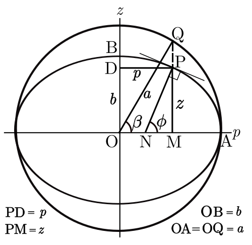
Definition of the parametric latitude (β) on the ellipsoid

A sphere of radius a compressed along the z axis to form an oblate ellipsoid of revolution.
Earth model with circles of latitude in black and indications of the North Pole, Equator, and the northern and southern hemispheres.
A perspective view of the Earth showing how latitude ( ϕ {displaystyle phi } ) and longitude ( λ {displaystyle lambda } ) are defined on a spherical model. The graticule spacing is 10 degrees.

The orientation of the Earth at the December solstice
The definition of geodetic latitude ( ϕ {displaystyle phi } ) and longitude ( λ {displaystyle lambda } ) on an ellipsoid. The normal to the surface does not pass through the centre, except at the equator and at the poles.

The definition of geodetic latitude (ϕ) and geocentric latitude (θ)
Definition of the parametric latitude (β) on the ellipsoid
A sphere of radius a compressed along the z axis to form an oblate ellipsoid of revolution.
Types Of Latitude
There are different types of latitude! 🌞The main ones are low, mid, and high latitude. Low latitude, like the Equator, has warm weather all year! ☀️ Mid-latitudes, like many places in the United States, have seasons – think summer and winter! ❄️ High latitude areas, such as Antarctica, are really cold and often have ice all around. 🌨️ These types help us understand what the weather will be like and what plants and animals might live in each area. It's fascinating how latitude affects our Earth!
Measuring Latitude
Measuring latitude is easy with a simple tool called a sextant! 🧭Sailors have used sextants for years to find their place on the ocean. The sextant helps them measure the angle of the sun or stars above the horizon. 🌠This tells them their latitude! Nowadays, we also have GPS technology that helps us find our latitude without using a sextant. When you use a smartphone to get directions, it uses latitude and longitude! So, how amazing is that? 🚀You can easily find your way around the world!
Understanding Latitude
Latitude helps us locate places on Earth. 🌎There are 180 lines of latitude, and each one tells us something important! The distance between each line is 69 miles (111 kilometers). For example, if you are at 30 degrees North latitude, you're halfway between the Equator and the North Pole! It's like a treasure map that helps us understand where we are! 🎯Latitude works with longitude, which measures east and west, to find exact locations. So, knowing your latitude makes it easier to explore our planet!
Latitude And Navigation
Latitude is crucial for navigation! 🚢In the past, sailors used to rely on the stars to find their latitude at sea. 🌠Today, we use satellites and GPS! When you're in a car or on an adventure, your GPS tells you your exact latitude and helps you get where you want to go! 🗺️ If you wanted to find your friend, you could share your latitude and longitude coordinates with them, making it super easy to meet up! The world is big, but latitude helps make it feel smaller!
Latitude And Time Zones
Latitude also helps us understand time around the world! ⏰The Earth spins, creating day and night as different parts face the sun. 🌞Longitude is more important for time zones, but latitude can still play a role! For example, places nearer to the Equator have similar day lengths throughout the year, while places farther away can have long summer days and short winter days. 🏙️ Understanding latitude helps us know how it feels in different places, whether it's light or dark outside!
Effects Of Latitude On Climate
Latitude greatly affects the climate in different parts of the world. 🌡️ Areas near the Equator (low latitude) are warm and get a lot of rain, making them great for rainforests! 🌴As you move toward the poles (high latitude), it gets colder. Places like Canada (about 60 degrees North) have cold winters and mild summers. ❄️ So, the farther you go from the Equator, the colder it usually gets! This is why polar bears can be found in the Arctic and not near the Equator! 🐻❄️
Cultural Significance Of Latitude
Latitude plays an important role in different cultures! 🌍Some cultures adapt to their climate based on latitude. For instance, in places near the Equator, people might wear lighter clothes because it's hot! 🌞In colder areas, like Siberia, people wear big, warm jackets! 🧥Additionally, different latitudes have special festivals that relate to their seasons. For example, some parts of the world celebrate the longest day of summer (around 60 degrees North) with lively festivals! 🎉Understanding latitude helps us appreciate the beautiful diversity of our planet!
Historical Perspectives On Latitude
Throughout history, knowing latitude has helped people explore and discover new lands! ⛵In the 15th century, explorers like Ferdinand Magellan used latitude measurements to navigate the oceans. 🌊They needed to know where they were to find new countries and trade routes. In ancient times, the Egyptians used the stars to determine latitude, paving the way for future explorers. 🌌Latitude's importance has not changed – it remains vital for sailors and travelers of today!
Geographical Applications Of Latitude
Latitude is useful for lots of geographical facts! 📈Scientists use latitude to study climate zones and ecosystems. For example, deserts often appear at around 30 degrees North and South latitude! 🌵They also use latitude to understand animal migration patterns. 🦋Birds will often fly long distances between locations based on latitude changes! Maps also use latitude lines to help us read them accurately. 🌍When you look at a globe, these lines guide adventurers and explorers to new places!
Latitude Quiz
Learn more about Latitude
