Euphrates Facts For Kids
The Euphrates is the longest river in Western Asia, historically significant for supporting ancient civilizations and cultures.


Do more with AI
Introduction
The Euphrates River is the longest river in Western Asia, stretching about 2,700 kilometers (1,700 miles)! 🌊It runs through countries like Turkey, Syria, and Iraq. The Euphrates is very special because it has been a home to many ancient civilizations, including the Mesopotamians, who are known for inventing writing! 🏺The river supplies water, food, and a way of traveling, making it vital for many people. The Euphrates is also one of the two rivers mentioned in the Bible, making it important to many religious stories. 🌍
Images of Euphrates
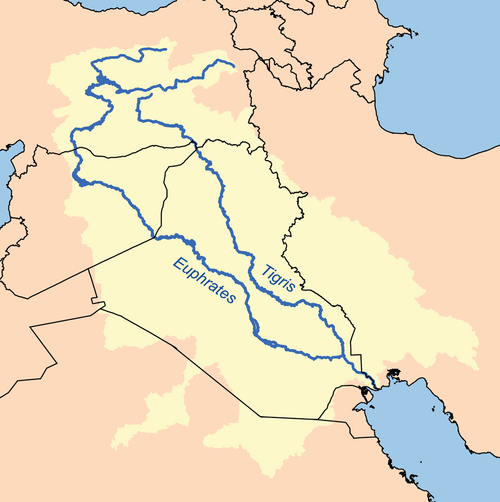
This is a map of the Tigris - Euphrates Watershed. I, Karl Musser , created it based on USGS data.
Plan, topographic representation of Babylon. The clay tablet depicts "Tu-ba", a suburb of the ancient city of Babylon. The River Euphrates is represented by the water-lined band. 660-500 BCE. British Museum

View of the Murat River

French map from the 17th century showing the Euphrates and the Tigris

Rafetus euphraticus
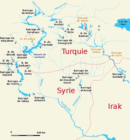
Map (in French) showing the locations of dams and barrages built in the Syro–Turkish part of the Euphrates basin
 Image by Heinz it up 57 at en.wikipedia, licensed under Creative Commons Attribution-Share Alike 2.5
Keban Dam in Turkey, the first dam on the Euphrates after it emerges from the confluence of the Kara Su and the Murat Su

Qal'at Ja'bar in Syria, once perched on a hilltop overlooking the Euphrates valley but now turned into an island by the flooding of Lake Assad

A fishing boat in the Euphrates Southern Iraq
This is a map of the Tigris - Euphrates Watershed. I, Karl Musser , created it based on USGS data.

Plan, topographic representation of Babylon. The clay tablet depicts "Tu-ba", a suburb of the ancient city of Babylon. The River Euphrates is represented by the water-lined band. 660-500 BCE. British Museum
View of the Murat River
French map from the 17th century showing the Euphrates and the Tigris
Rafetus euphraticus
Map (in French) showing the locations of dams and barrages built in the Syro–Turkish part of the Euphrates basin
Image by Heinz it up 57 at en.wikipedia, licensed under Creative Commons Attribution-Share Alike 2.5Keban Dam in Turkey, the first dam on the Euphrates after it emerges from the confluence of the Kara Su and the Murat Su
Qal'at Ja'bar in Syria, once perched on a hilltop overlooking the Euphrates valley but now turned into an island by the flooding of Lake Assad
A fishing boat in the Euphrates Southern Iraq
This is a map of the Tigris - Euphrates Watershed. I, Karl Musser , created it based on USGS data.
Plan, topographic representation of Babylon. The clay tablet depicts "Tu-ba", a suburb of the ancient city of Babylon. The River Euphrates is represented by the water-lined band. 660-500 BCE. British Museum
View of the Murat River
French map from the 17th century showing the Euphrates and the Tigris
Rafetus euphraticus
Map (in French) showing the locations of dams and barrages built in the Syro–Turkish part of the Euphrates basin
Image by Heinz it up 57 at en.wikipedia, licensed under Creative Commons Attribution-Share Alike 2.5Keban Dam in Turkey, the first dam on the Euphrates after it emerges from the confluence of the Kara Su and the Murat Su
Qal'at Ja'bar in Syria, once perched on a hilltop overlooking the Euphrates valley but now turned into an island by the flooding of Lake Assad
A fishing boat in the Euphrates Southern Iraq
Cultural Impact
The Euphrates has inspired many stories, myths, and legends! 🌌In ancient times, it was thought to be a river of gods and goddesses. People would pray to the river for good harvests and good fortune. Many famous artists and writers, like the poet Homer, mentioned the Euphrates in their work! 🎨Even today, people celebrate the river with festivals and music. The traditions of the cultures along the Euphrates continue to influence the way people live and celebrate life. 🎉
Flora And Fauna
The Euphrates River is home to many exciting plants and animals! 🌳Various trees, like willows and poplars, grow near the banks, providing shade and homes for different creatures. The river is also home to fish like the catfish and tilapia 🎣. Birds such as herons and eagles can often be seen flying overhead or searching for food in the water. The wetland areas near the river provide rich habitats for animals, making it a vibrant ecosystem filled with life! 🌿
Modern Challenges
Despite its importance, the Euphrates faces some big challenges today! 🚧The growing population and climate change are putting pressure on its water supply. Sometimes, there isn't enough water for everyone, which can cause conflicts between countries. 🌍Pollution is also a problem, as factories and farms can dirty the water. People are working hard to protect the river to ensure it remains a resource for future generations! 🌿Learning about these issues is essential for caring for our planet.
Economic Importance
The Euphrates plays a big role in the economy of the countries it flows through! 🏦People rely on the river for fishing, farming, and trade. The river provides water for irrigation 🔄, helping farmers grow crops like rice and cotton. This means jobs and food for many families! In some areas, they use the river to create hydroelectric power, which helps supply electricity. ⚡All of these activities help the communities thrive and grow, making the Euphrates an essential resource!
Mythology And Religion
In many cultures, the Euphrates River is a symbol of life and fertility. 🌱In ancient Mesopotamian myths, the river was often associated with gods like Enki, the god of water! 🌊The Euphrates is also mentioned in the Bible, where it is described as a part of the Garden of Eden. Many people celebrate the river in their traditions and stories, seeing it as a part of their history. Today, the river continues to inspire faith and cultural ceremonies, reminding us of its deep significance! 🙏
Tourism And Recreation
The Euphrates River attracts many visitors each year! 🚣People enjoy activities like boating, fishing, and picnicking along its banks. 🌅In cities like Babylon, tourists can watch beautiful sunsets and explore ancient ruins. Some adventurous folks even like to go rafting! 🛶The river's beauty and historical sites make it a wonderful place for learning and fun. Plus, many festivals happen along the Euphrates, bringing people together to celebrate culture and tradition! 🎊So, if you ever visit, there will be so much to see and do!
Historical Significance
The Euphrates River has been super important throughout history! Ancient civilizations like the Sumerians and Babylonians grew up alongside this river. 🌟They used the water for farming, which meant they could grow crops like wheat and barley! 🍞The river also allowed people to trade goods and travel easily. One famous story is the Hanging Gardens of Babylon, which were said to be near the Euphrates! 🌿This river has witnessed many great events, helping to shape the history we learn about today.
Geography Of The Euphrates
The Euphrates River begins in the Taurus Mountains of Turkey and flows through beautiful landscapes. 🌄It travels south into Syria and finally reaches Iraq, where it meets the Tigris River. The Euphrates runs through long valleys and plain areas and is surrounded by deserts 🏜️. The river creates rich lands called riverbanks where plants and animals can thrive! Did you know that it runs alongside ancient cities like Babylon? 🏙️ This area is known as Mesopotamia, which means "between rivers."
Water Management And Irrigation
Water management is super important for life along the Euphrates! 💧The river has lots of people using its water for farming and daily needs. To make sure everyone gets enough water, countries have built dams and canals. These structures help to control how much water flows to farms and cities. One famous dam is the Atatürk Dam in Turkey, which creates electricity and stores water for irrigation. 🌊With proper water management, people can grow more food and support their communities even when there are dry spells!
Did you know?
🌊 The Euphrates River is the longest river in Western Asia, stretching about 2,700 kilometers (1,700 miles)!
🏺 Ancient civilizations like the Mesopotamians lived along the Euphrates and are known for inventing writing!
🌍 The Euphrates is one of the two rivers mentioned in the Bible, making it important to many religious stories.
🌄 The river begins in the Taurus Mountains of Turkey and flows through beautiful landscapes into Iraq.
🏜️ The Euphrates runs alongside ancient cities, like Babylon, in an area known as Mesopotamia.
🍞 Farmers along the Euphrates grow crops like wheat and barley thanks to its water!
🌟 The Hanging Gardens of Babylon, a famous ancient wonder, were said to be near the Euphrates!
🎉 Many cultures along the Euphrates celebrate the river with festivals and music.
🌳 The river banks are home to various plants and animals, making it a vibrant ecosystem.
⚡ The Euphrates is used for hydroelectric power generation, helping supply electricity to communities.
Euphrates Quiz
Learn more about Euphrates
