Find your hardiness zone
Use a map, local climate data, and temperature records to find your USDA hardiness zone, then plan plants suited to your area.


Step-by-step guide to find your hardiness zone
What Is the Habitable Zone?
Step 1
Write your town or the closest city and state at the top of a page in your notebook.
Step 2
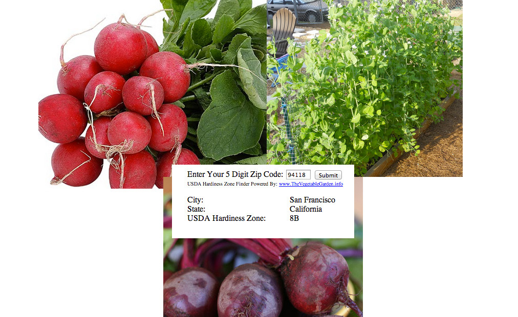
Open the USDA Hardiness Zone Map or the online hardiness map and find your town on the map.
Step 3
Look at the map legend and write down the zone number that matches your town.
Step 4
Find local climate records that show the average annual extreme minimum temperature and write that temperature in your notebook.
Step 5
Match the temperature you found to the temperature ranges in the map legend to confirm your hardiness zone.
Step 6
Make a list of five plants you would like to grow in your notebook.
Step 7
For each plant on your list check the hardiness zones on seed packets or a plant info guide and mark which plants are safe for your zone.
Step 8
Cross out any plants that are not safe for your zone and choose replacements for each crossed out plant.
Step 9
Draw a simple garden plan in your notebook showing sunny spots and shady spots.
Step 10
Place each suitable plant on your drawn garden plan where it will get the right sun or shade.
Step 11
Write the bloom time and how far apart each plant needs to be next to its name on your plan.
Step 12
Make a simple care schedule listing watering frequency and key frost dates for your plants.
Step 13
Color your garden plan with your coloring materials.
Step 14
Share your finished garden plan and notes on DIY.org.
Help!?
What can we use instead of a notebook or the USDA Hardiness Zone Map if we don't have them?
If you don't have a notebook, use a printable worksheet or a notes app on a tablet, and if you can't open the USDA Hardiness Zone Map online, check your county extension website or NOAA climate pages to find your town's hardiness info and extreme minimum temperature as in steps 1–4.
I can't find my town on the map or my local climate records don't match the zone shown—what should we do?
If your town isn't on the map or the zone looks different, enter your ZIP code on the USDA map, or use the average annual extreme minimum temperature from your nearest weather station and match it to the map legend as described in steps 2–5.
How can we make this activity easier for little kids or more challenging for older kids?
For younger children, simplify steps 6–13 by choosing three easy plants, using stickers and pre-drawn garden templates to place them and color the plan, while older kids can research five or more plants' zone ranges, calculate exact spacing in inches for step 11, and build a detailed watering and frost-date care schedule in step 12.
What are some creative ways to extend or personalize our garden plan after finishing the steps?
Extend the project by measuring your real garden bed and recording sun hours before you draw the plan (step 9), making waterproof plant labels, creating a month-by-month planting calendar tied to your key frost dates (step 12), and posting progress photos on DIY.org as suggested in step 14.
Watch videos on how to find your hardiness zone
Tomatoes Shed Light on How Plants Fight Drought | National Geographic
4 Videos
Tomatoes Shed Light on How Plants Fight Drought | National Geographic

A Level Biology Revision "Xerophytic Adaptations of Plants"
Can Planting Trees Fix Climate Change? (Plants & Biomes): Crash Course Botany #14
Products Help Gardeners Grow Greener
Facts about plant hardiness zones
🗺️ The USDA Plant Hardiness Zone Map divides North America into 13 zones based on average annual minimum winter temperatures.
🌡️ Each whole-number hardiness zone represents a 10°F difference in average extreme minimum temperature (zones are split into 5°F 'a' and 'b' subzones).
🌱 Plant labels often list the coldest zone a species can tolerate — if a plant is hardy to zone 5, it should survive winters in zone 5 and warmer zones.
🗓️ Hardiness zones are calculated from long-term climate records (typically 30 years), so they reflect averages rather than one-off cold snaps.
🔥 Because of warming, many locations shifted one or more zones when the USDA updated its map in 2012.
How do we find our USDA hardiness zone using a map and local temperature records?
What materials and tools do we need to find our hardiness zone?
What ages is this hardiness-zone activity suitable for?
What are the benefits of finding your hardiness zone and how can we vary the activity?
