Geomorphology Facts For Kids
Geomorphology is the scientific study of the origin and evolution of topographic and bathymetric features generated by physical, chemical, or biological processes operating at or near Earth's surface.


Do more with AI
Introduction
Geomorphology is the study of landforms and how they change over time. 🌍It looks at mountains, valleys, rivers, and even underwater features! Geomorphologists, scientists who study these shapes, want to understand how the Earth was formed and what changes happen. For example, the Grand Canyon in the USA was shaped over millions of years by the Colorado River. ⛰️ Learning about geomorphology helps us understand our planet better, and why it looks the way it does now! It’s like being a detective of Earth’s history! 🕵️♂️
Images of Geomorphology

Lake "Veľké Hincovo pleso" in High Tatras, Slovakia. The lake occupies an "overdeepening" carved by flowing ice that once occupied this glacial valley.
![Part of the Great Escarpment in the Drakensberg, southern Africa. This landscape, with its high altitude plateau being incised into by the steep slopes of the escarpment, was cited by Davis as a classic example of his cycle of erosion.[33]](https://upload.wikimedia.org/wikipedia/commons/thumb/a/ac/South_Africa-Mpumalanga-Gods_Window002.jpg/500px-South_Africa-Mpumalanga-Gods_Window002.jpg)
Part of the Great Escarpment in the Drakensberg, southern Africa. This landscape, with its high altitude plateau being incised into by the steep slopes of the escarpment, was cited by Davis as a classic example of his cycle of erosion.[33]

Gorge cut by the Indus River into bedrock, Nanga Parbat region, Pakistan. This is the deepest river canyon in the world. Nanga Parbat itself, the world's 9th highest mountain, is seen in the background.

Wind-eroded alcove near Moab, Utah

Beaver dams, as this one in Tierra del Fuego, constitute a specific form of zoogeomorphology, a type of biogeomorphology.

Seif and barchan dunes in the Hellespontus region on the surface of Mars. Dunes are mobile landforms formed by the transport of large volumes of sand by wind.
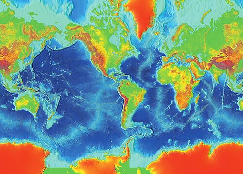
Surface of Earth, showing higher elevations in red
 Image by Christopher Michel from San Francisco, USA, licensed under Creative Commons Attribution 2.0
Waves and water chemistry lead to structural failure in exposed rocks.
!["Cono de Arita" at the dry lake Salar de Arizaro on the Atacama Plateau, in northwestern Argentina. The cone itself is a volcanic edifice, representing complex interaction of intrusive igneous rocks with the surrounding salt.[10]](https://upload.wikimedia.org/wikipedia/commons/thumb/9/9e/Cono_de_Arita%2C_Salar_de_Arizaro_%28Argentina%29.jpg/500px-Cono_de_Arita%2C_Salar_de_Arizaro_%28Argentina%29.jpg)
"Cono de Arita" at the dry lake Salar de Arizaro on the Atacama Plateau, in northwestern Argentina. The cone itself is a volcanic edifice, representing complex interaction of intrusive igneous rocks with the surrounding salt.[10]
Lake "Veľké Hincovo pleso" in High Tatras, Slovakia. The lake occupies an "overdeepening" carved by flowing ice that once occupied this glacial valley.
Part of the Great Escarpment in the Drakensberg, southern Africa. This landscape, with its high altitude plateau being incised into by the steep slopes of the escarpment, was cited by Davis as a classic example of his cycle of erosion.[33]
Gorge cut by the Indus River into bedrock, Nanga Parbat region, Pakistan. This is the deepest river canyon in the world. Nanga Parbat itself, the world's 9th highest mountain, is seen in the background.
Wind-eroded alcove near Moab, Utah
Beaver dams, as this one in Tierra del Fuego, constitute a specific form of zoogeomorphology, a type of biogeomorphology.
Seif and barchan dunes in the Hellespontus region on the surface of Mars. Dunes are mobile landforms formed by the transport of large volumes of sand by wind.
Major Landform Types
There are many exciting landforms to discover! Mountains are tall and rocky, while valleys are low areas where rivers often flow. 🏔️ Plains are flat lands that are great for farming, and plateaus are flat raised areas. 🏞️ Deserts have very little water, making them sandy and dry. 🌵Islands are pieces of land surrounded by water, and beaches are where land meets the sea. 🏖️ Each landform has its unique way of forming and changing, making our planet diverse and beautiful!
Processes Shaping Landforms
Different processes shape our landforms every day! 🌊Water can create canyons by cutting through rock over time. Wind can shape sand dunes by blowing sand around. 🌬️ Plants and animals can also change land. For instance, tree roots can break rocks apart! 🌳Earthquakes and volcanoes can change landscapes suddenly, creating new mountains or lakes. ⛰️ All these processes combine to change the shape of Earth, reminding us that it’s always evolving!
Case Studies In Geomorphology
Scientists study many exciting places to learn about geomorphology! 🌄For instance, they look at the Great Barrier Reef in Australia to understand underwater landforms shaped by coral. 🐠The Amazon River in South America is studied for its winding paths that create unique valleys. 🌊Another case is the Himalayas, where researchers study how mountains form from tectonic activity! ⛰️ By investigating these places, scientists can learn how landforms happen and help protect Earth's natural beauty! 🌍
Human Influence On Landscapes
Humans greatly influence landscapes! We build cities, roads, and farms, reshaping the land. 🏙️ For example, when we dig out land for buildings or dams, we change rivers' flow and create new lakes! 🌊Deforestation, which is cutting down trees, can lead to soil erosion. 🌳We also create parks and gardens, adding beauty to our surroundings. However, it’s important to be kind to the Earth and consider how our actions fit into geomorphology, so we can protect our planet for future generations! 🌍
Key Concepts In Geomorphology
Some important ideas in geomorphology include weathering, erosion, and sedimentation. Weathering is when rocks break down into smaller pieces due to wind, water, or sunlight. 🌧️ Erosion happens when those pieces are moved elsewhere by forces like wind or rivers. Lastly, sedimentation is when the moved soil and rocks settle in a new place, creating new landforms! These processes can take thousands to millions of years! 🕰️ Understanding these terms is like learning how Earth's features are built and changed over time!
Tectonic Processes And Landforms
Tectonic processes occur deep within the Earth and help shape landforms too! 🌏The Earth's crust is made of big plates that slowly move. Sometimes, these plates push against each other, forming mountains like the Himalayas! ⛰️ Other times, they pull apart and create valleys or rift zones. 🌊Earthquakes happen when these plates suddenly slip, changing landscapes in a big way! Even volcanoes are formed when magma pushes through the crust. 🌋Tectonic processes make the Earth’s surface exciting, with new landforms evolving all the time!
Role Of Erosion And Sedimentation
Erosion and sedimentation are very important processes in geomorphology! Erosion is like a natural cleanup crew. 🌪️ It moves soil and rocks away from one place to another. This helps in forming new land. For instance, when a river erodes, it can create valleys or canyons over time. Meanwhile, sedimentation is like a puzzle. When the eroded pieces land in another place, they build up and create new features, such as deltas at river mouths! 🌊Together, erosion and sedimentation help shape our beautiful landscape!
Geomorphological Mapping Techniques
Geomorphologists use special tools to create maps of landforms! 🗺️ They use aerial photography, which takes pictures from above, and satellite images to see the Earth’s surface. 📸They also study topographic maps that show the heights of mountains and depths of valleys. Using tools like drones and GPS helps them collect detailed information on landscapes! 🚁These maps help scientists understand how landforms are shaped and how to protect them. Mapping is like telling a story of Earth through pictures and data!
Impact Of Climate On Landform Development
Climate plays a big role in how landforms develop! 🌤️ In rainy areas, rivers are stronger and can carve deeper valleys. In deserts, wind erosion creates unique shapes like sand dunes. 🌵Cold climates can cause glaciers to form, which carve out mountains. ❄️ Warm and wet climates foster lush forests that can prevent erosion. 🌳Each climate area creates different landforms, highlighting how climate and land interact in beautiful ways! Understanding this helps us see how diverse the Earth can be!
Geomorphology Quiz
Learn more about Geomorphology
