Geodesy Facts For Kids
Geodesy is the science of measuring and representing the Earth's geometry, gravity, and orientation in 3D.


Do more with AI
Introduction
Geodesy is a science that helps us understand our planet! 🌍It measures the Earth's shape, size, and position in space. Think of it like a giant puzzle where scientists figure out how everything fits together. Geodesy helps with maps, GPS, and even locating places on Earth! 🌐Have you ever wondered how your favorite video game finds your location? That's geodesy in action! By studying the Earth, geodesists help in many areas like navigation, building, and even weather forecasting. Understanding geodesy helps us take care of our world better! 🌱
Images of Geodesy


A modern instrument for geodetic measurements using satellites

Geoid, an approximation for the shape of the Earth; shown here with vertical exaggeration (10000 vertical scaling factor).

Ellipsoid - a mathematical representation of the Earth. When mapping in geodetic coordinates, a latitude circle forms a truncated cone.
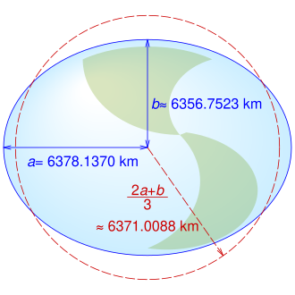
Equatorial (a), polar (b) and mean Earth radii as defined in the 1984 World Geodetic System

Datum shift between NAD27 and NAD83, in metres

2D grid for elliptical coordinates

A Munich archive with lithography plates of maps of Bavaria

Height measurement using satellite altimetry

GPS Block IIA satellite orbits over the Earth.
Satellite Geodesy
Satellite geodesy is an amazing part of geodesy! 🚀It uses satellites orbiting Earth to collect data about land, water, and the atmosphere. These satellites send information back to Earth, helping scientists in many ways! For example, they measure land movements and changes in sea levels. 🌊NASA has satellites like GRACE that measure water movement, showing us where freshwater goes. It helps us understand climate change! 🌡️ Without satellite geodesy, our knowledge of our planet would be much less advanced. Satellites give us a bird’s-eye view of Earth like never before! 🦅
History Of Geodesy
The history of geodesy goes back thousands of years! 🕰️ Ancient Egyptians made early measurements to build the huge pyramids. Around 200 BCE, a Greek scientist named Eratosthenes calculated Earth's circumference using shadows in different locations. Amazing, right? 🌞In the 18th century, Isaac Newton added to this knowledge with gravity studies, helping geodesy grow. With technology advancing, in the 20th century, the invention of satellites took geodesy to new heights—literally! 🚀Now, scientists can measure the Earth from space, providing even more accurate information than ever before!
Applications Of Geodesy
Geodesy has many exciting applications! 🌈For example, it helps in creating accurate maps for navigation, so we don't get lost on road trips! 🚗It's also used in construction projects to ensure buildings are level and safe. Geodesy helps scientists track earthquakes too! 🌋By measuring the Earth’s movements, they can predict where earthquakes might happen. Geodesy is super important for preserving the environment, too, by monitoring sea level rise. 🌊With its many uses, geodesy helps improve our lives in countless ways!
Geoid And Its Importance
The geoid is a fascinating concept in geodesy! 🌊Imagine the Earth as a big, squishy ball. The geoid is its shape when only gravity and rotation are involved, kind of like a sea level around the globe. It helps scientists know where the Earth's surface is "normal." 🗺️ Knowing the geoid is super important for navigation and map-making because it serves as a reference for heights and depths! It helps pilots know how high to fly and boats navigate safely! 🚢Without the geoid, understanding the Earth would be much trickier!
Techniques Used In Geodesy
Geodesists use many cool techniques to measure the Earth! 📐One way is by using the Global Positioning System (GPS), which helps pinpoint locations on Earth using satellites. 🌟They also use tools like levels and theodolites for land surveying, which helps in construction and engineering. Some scientists measure distances by bouncing radio waves off satellites! 📡Others even measure the height of mountains using laser beams! Each technique helps geodesists get more information so we can understand our world better!
Fundamental Concepts In Geodesy
Geodesy uses some important concepts! One key idea is the "geoid," which is like an imaginary shape of the Earth that shows sea level everywhere. 🌊Another concept is "coordinates," which are like a special address telling us where something is located. Every place on Earth has a unique coordinate, like a treasure map! 🗺️ Geodesists also study gravity, which is why things fall down. 🍏Learning these concepts helps geodesists create accurate maps and understand how the Earth changes over time! 🌏
Geodetic Measurements And Tools
Geodetic measurements require some special tools! 🛠️ One essential tool is the Total Station, which measures distances and angles. It's like a super smart ruler! 📏GPS devices help determine locations with great precision, while leveling instruments show how flat or sloped an area is. Some scientists even use satellites that measure gravity changes. 🌌A cool tool called the "GNSS" uses Global Navigation Satellite Systems to get accurate positions globally! These tools and measurements help in many areas, from building cities to tracking the Earth's changes over time. 🏙️
Geodesy In Climate Change Studies
Geodesy plays a crucial role in studying climate change! 🌦️ Scientists use geodesy to measure how sea levels rise due to melting ice from glaciers and polar caps. 🌨️ This helps us know how coastal areas could be affected. Geodesists use satellites to track changes in land movement and temperature, crucial for predicting weather patterns. 🌡️ This information helps us plan for natural disasters, protect wildlife habitats, and understand how to take climate action! 🌎Every bit of data helps us protect our planet for future generations!
Comparative Geodesy: Earth Vs. Other Celestial Bodies
Did you know geodesy isn't just for Earth? 🌌Scientists use geodesy to study other planets, too! For example, the Moon has a shape called the "lunar geoid," which is studied using spacecraft. The same techniques help understand Mars' surface and gravity. 🚀Geodesy helps us learn if future visits to other planets are safe! By comparing Earth to planets like Jupiter and Saturn, scientists can understand how different environments affect landscapes. 🌠This "comparative geodesy" helps uncover the mysteries of our universe! 🌌Learning about other celestial bodies expands our knowledge of the cosmos!
Geodesy Quiz
Learn more about Geodesy
