Mount Rainier Facts For Kids
Mount Rainier is an iconic active stratovolcano and the tallest peak in Washington state, renowned for its stunning natural beauty and extensive recreational opportunities.


Do more with AI
Introduction
Mount Rainier is a stunning and tall volcano located in Washington State, USA! 🗻It stands at 14,411 feet (4,392 meters) high, making it the tallest mountain in the Cascade Range. Mount Rainier is famous for its beautiful, snow-covered peak, and it can be seen from many miles away! The mountain is part of Mount Rainier National Park, home to amazing wildlife, scenic views, and over 260 miles of trails. It's a great place for adventure and fun! 🌲💚 Can you imagine climbing all the way to the top? Many people visit to see its beauty and enjoy nature!
Images of Mount Rainier


Mount Rainier seen from the International Space Station

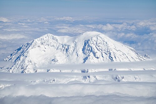
The Boeing 767 Prototype N767BA flying near Mount Rainier

Little Tahoma Peak to the left of Mount Rainier, from Panhandle Gap

Hazard map

The summit of Mount Rainier showing summit calderas and the mountain's glaciers.

One of many emergency evacuation route signs in case of volcanic eruption or lahar around Mount Rainier

Three-dimensional representation of Mount Rainier
Mount Rainier seen from the International Space Station
The Boeing 767 Prototype N767BA flying near Mount Rainier
Little Tahoma Peak to the left of Mount Rainier, from Panhandle Gap
Hazard map
The summit of Mount Rainier showing summit calderas and the mountain's glaciers.
One of many emergency evacuation route signs in case of volcanic eruption or lahar around Mount Rainier
Three-dimensional representation of Mount Rainier
Flora And Fauna
The plant life around Mount Rainier is diverse and beautiful! 🌸There are over 900 species of wildflowers in the park! In spring, the meadows burst with colors, making it a perfect spot for photos. Some common plants include lupines, rhododendrons, and Indian paintbrush. 🌼You'll also find many animals, like black bears, elk, and deer, roaming the forests. 🦌In the rivers, you can see salmon swimming upstream! The mountain is a home to over 200 species of birds, including the majestic bald eagle. Mount Rainier is truly a paradise for nature lovers!
Climate And Weather
Mount Rainier has a variety of weather conditions due to its height! ☀️ In the summer, temperatures can be warm, around 70°F (21°C), while winter brings lots of snow! ❄️ The mountain gets about 643 inches (16,300 mm) of snowfall each year, making it one of the snowiest places in the world! 🌨️ The weather can change quickly; it might be sunny one moment and snowing the next! That's why visitors need to dress in layers when they go hiking or climbing. Mount Rainier's climate creates beautiful landscapes throughout the seasons!
Visitor Information
Planning a trip to Mount Rainier is exciting! 🎒The park is open year-round, but certain areas may be closed in winter due to snow. The entrance fee is $30 for a vehicle, which is valid for seven days. There are visitor centers to learn more about the park and pick up maps. 📍Make sure to dress for the weather, bring water, and have snacks! Campgrounds are available, but it’s a good idea to reserve a spot in advance. Whether hiking, playing, or exploring, Mount Rainier offers an unforgettable adventure! 🌞
Conservation Efforts
To keep Mount Rainier beautiful, many people work hard to protect it! 🌿The National Park Service takes care of the park and its wildlife, ensuring clean air and water. Visitors are encouraged to follow "Leave No Trace" principles, which means not littering and respecting wildlife. 🦉Many groups participate in volunteer programs to help with park clean-ups and trail maintenance. Protecting Mount Rainier helps preserve this amazing mountain for future generations so everyone can enjoy its beauty and learn about its history. 🌍Together, we can all help!
Cultural Significance
Mount Rainier is not just a national treasure; it has deep cultural significance! 🏞️ The local Indigenous people, including the Puyallup and other tribes, have lived in the area for thousands of years. They view Mount Rainier as a sacred place, rich in stories and traditions. The mountain is known as "Tahoma" or "Mount Tacoma" in their languages. 🌌The beauty of Mount Rainier has inspired art, poetry, and many people’s love for nature. The mountain teaches us about respect for the environment and the importance of preserving nature and culture!
Geology And Formation
Around 500,000 years ago, Mount Rainier began as volcanic eruptions. 🌋The mountain is made of layers of lava and ash, creating its unique shape. It’s an active volcano, which means it could erupt again! The last eruption occurred in 1894. Because of its height and glaciers, Mount Rainier is constantly changing, with rocks and ice moving. Scientists study the mountain to understand how it was formed and what might happen in the future. 🔬Each year, the mountain receives lots of snow, shaping its majestic appearance and making it a magical place to explore!
Geography And Location
Mount Rainier is located in the Cascade Mountain Range, about 54 miles (87 kilometers) southeast of Seattle. 🌆The mountain towers over the surrounding landscape, and its stunning glaciers can be seen up close. The area has rivers and lush forests filled with tall trees like Douglas firs and cedar. Mount Rainier National Park covers 368 square miles (955 square kilometers) of wild beauty! 🎉The park features different ecosystems, from lush valleys to rocky subalpine areas. Visitors can explore all these incredible landscapes in one amazing place!
Recreation And Activities
There are so many fun things to do at Mount Rainier! 🥾You can hike, camp, and even climb to the summit! There are trails for everyone, from little kids to experienced hikers. Some popular trails include the Skyline Trail and the Wonderland Trail. 🌳In the summer, visitors enjoy picnicking and wildflower viewing, while wintertime is perfect for snowshoeing and skiing. ⛷️ Many people come to take photographs and enjoy the breathtaking views. The park also offers ranger-led programs to learn more about the mountain. Adventure awaits at Mount Rainier!
Mount Rainier Quiz
Learn more about Mount Rainier
