Andaman Sea Facts For Kids
The Andaman Sea is a beautiful, vibrant sea in the northeastern Indian Ocean, bordered by Myanmar and Thailand, home to stunning islands and diverse marine life.


Do more with AI
Introduction
The Andaman Sea is a beautiful part of the northeastern Indian Ocean. 🌊It's special because it's surrounded by places like Myanmar and Thailand. The Gulf of Martaban is on the northwest side, while the Andaman Islands and Nicobar Islands can be found nearby. This sea is around 1,200 kilometers long and has many islands, making it a fascinating area. Did you know that the Andaman Sea is home to many amazing fish and coral reefs? 🐠Everyone loves to explore its clear blue waters!
Images of Andaman Sea

Satellite image of the Andaman Sea showing the green algae and silt deposits due to the Irrawaddy River in its northern part
![The bathymetry (in metres) of the Andaman Sea in 2D and 3D (sectioned along 95°E)[3]](https://upload.wikimedia.org/wikipedia/commons/thumb/2/2b/The_Bathymetry_%28in_metres%29_of_A-SEA_in_2D_and_3D_%28sectioned_along_95E%29.png/500px-The_Bathymetry_%28in_metres%29_of_A-SEA_in_2D_and_3D_%28sectioned_along_95E%29.png)
The bathymetry (in metres) of the Andaman Sea in 2D and 3D (sectioned along 95°E)[3]
![Percentage of the total area of Andaman Sea corresponding to different depth ranges[3]](https://upload.wikimedia.org/wikipedia/commons/thumb/d/da/Percentage_of_total_area_of_A-SEA_corresponding_to_diferent_ranges_of_depth.png/500px-Percentage_of_total_area_of_A-SEA_corresponding_to_diferent_ranges_of_depth.png)
Percentage of the total area of Andaman Sea corresponding to different depth ranges[3]
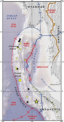
The Andaman Sea, showing tectonic plate boundaries

Tectonic setting of Sumatra earthquake (2004)

Eruption of the Barren Island volcano in 1995. Andaman Islands (on top) are c. 90 km distant
![Monthly averaged winds in the Andaman Sea for the year 2011, expressed in mps[3]](https://upload.wikimedia.org/wikipedia/commons/thumb/c/cc/Monthly_averaged_ASCAT_winds_in_ANDAMAN_SEA_for_the_year_2011%2C_expressed_in_mps.png/500px-Monthly_averaged_ASCAT_winds_in_ANDAMAN_SEA_for_the_year_2011%2C_expressed_in_mps.png)
Monthly averaged winds in the Andaman Sea for the year 2011, expressed in mps[3]
![Monthly averaged Ekman pumping velocity (in m per day) for June and December[3]](https://upload.wikimedia.org/wikipedia/commons/thumb/f/f2/Monthly_averaged_Ekman_Pumping_velocity_%28in_m_per_day%29_for_June_and_December.png/500px-Monthly_averaged_Ekman_Pumping_velocity_%28in_m_per_day%29_for_June_and_December.png)
Monthly averaged Ekman pumping velocity (in m per day) for June and December[3]
![Monthly averaged OSCAR surface currents in January, April, June, and October, expressed in cm/s[3]](https://upload.wikimedia.org/wikipedia/commons/thumb/c/cf/Monthly_averaged_OSCAR_surface_currents_in_January%2C_April%2C_June_and_October%2C_expressed_in_cmps.png/500px-Monthly_averaged_OSCAR_surface_currents_in_January%2C_April%2C_June_and_October%2C_expressed_in_cmps.png)
Monthly averaged OSCAR surface currents in January, April, June, and October, expressed in cm/s[3]
Satellite image of the Andaman Sea showing the green algae and silt deposits due to the Irrawaddy River in its northern part
The bathymetry (in metres) of the Andaman Sea in 2D and 3D (sectioned along 95°E)[3]
Percentage of the total area of Andaman Sea corresponding to different depth ranges[3]
The Andaman Sea, showing tectonic plate boundaries
Tectonic setting of Sumatra earthquake (2004)
Eruption of the Barren Island volcano in 1995. Andaman Islands (on top) are c. 90 km distant
Monthly averaged winds in the Andaman Sea for the year 2011, expressed in mps[3]
Monthly averaged Ekman pumping velocity (in m per day) for June and December[3]
Monthly averaged OSCAR surface currents in January, April, June, and October, expressed in cm/s[3]
Historical Context
The Andaman Sea has a rich history! 📜It has been explored and visited by many famous explorers throughout time. The British Empire used the Andaman Islands for a penal colony during the 19th century, meaning they sent prisoners there. This changed the islands' population and culture! The sea has also been important during different wars, like World War II, when it was used for naval activities. Understanding this history helps us appreciate the importance of the Andaman Sea today!
Economic Importance
The Andaman Sea is important for many reasons! 🌊One big reason is fishing. Many people in surrounding countries catch fish from the sea to eat and sell. 🐟It's also important for transportation. Bigger ships use this sea to carry goods to and from countries like India, Thailand, and Myanmar. Tourism is another big part of the economy! People visit the beautiful beaches and islands to enjoy the sun and explore the colorful underwater world. This brings money to local businesses and helps improve the community.
Cultural Significance
The Andaman Sea holds cultural importance for many people! 🌍The islands are home to various indigenous tribes, like the Jarwa and Sentinelese. These tribes have unique traditions and ways of life that have been passed down through generations. The sea also connects people through trade and tourism, allowing for cultural exchange. Festivals, folklore, and traditional music showcase the rich heritage of the area. 🌺Understanding and respecting local cultures is essential while visiting this beautiful region!
Environmental Concerns
The Andaman Sea faces many environmental concerns. 🌎One big issue is pollution from boats and people visiting the beaches. Plastic waste can harm marine life and coral reefs. 🌊Climate change is also affecting the sea, causing temperatures to rise and coral bleaching. Protecting these ecosystems is crucial for the survival of the amazing creatures that call the Andaman Sea home. Conservation efforts are important to maintain the beauty and health of this special sea for future generations!
Geography And Location
The Andaman Sea is located between some very interesting places! 🌏To the west, you find Myanmar (formerly Burma) and Thailand, which have beautiful beaches. On the southwest side is the famous Malay Peninsula. The sea is separated from the Bay of Bengal by the Andaman and Nicobar Islands. These islands are home to many unique animals and plants. The latitude and longitude of the sea are approximately 10° North and 93° East. This sea plays a big role in connecting these amazing countries! 🗺️
Tourism And Recreation
Tourism is very popular in the Andaman Sea! 🏖️ People from all over the world flock to see its stunning beaches, clear waters, and rich marine life. The Andaman and Nicobar Islands are famous for activities like snorkeling, diving, and water sports. 🏄♂️ Tourists can explore underwater worlds filled with colorful fish and corals. Many visitors also enjoy relaxing on the soft sandy beaches. This region is a paradise for adventure lovers, making it a fantastic destination for families and friends!
Ecology And Marine Life
The Andaman Sea is a magical underwater world! 🐬It has colorful coral reefs that provide homes for many types of fish and sea creatures. Some species you can find include clownfish, sea turtles, and even dolphins! This sea is known for its biodiversity, which means it has many different kinds of plants and animals. 🌈The warm waters make it a great place for marine life to thrive. However, these ecosystems need to be protected to ensure the creatures continue living here for years to come!
Navigation And Shipping
The Andaman Sea is a busy waterway for navigation and shipping. 🚢Many ships travel through this sea to transport goods between countries like India, Thailand, and Myanmar. It is vital for trade in Southeast Asia because it connects major ports. 🌏Safe navigation is necessary, so ships follow specific routes to avoid encountering shallow areas or islands. Mariners use maps and technology to plot their courses. This navigational knowledge helps keep everyone safe while using the sea!
Research And Conservation Efforts
Many scientists study the Andaman Sea to protect its unique marine life! 🧑🔬 They are researching the ecosystems to understand how to keep them healthy and thriving. Conservation efforts focus on reducing pollution, protecting coral reefs, and preserving species like sea turtles and dolphins. 🐢Local communities are also involved in these efforts by participating in clean-up drives and efforts to raise awareness. By working together, we can ensure that the Andaman Sea remains a vibrant and beautiful place for future generations! 🌟
Andaman Sea Quiz
Learn more about Andaman Sea
